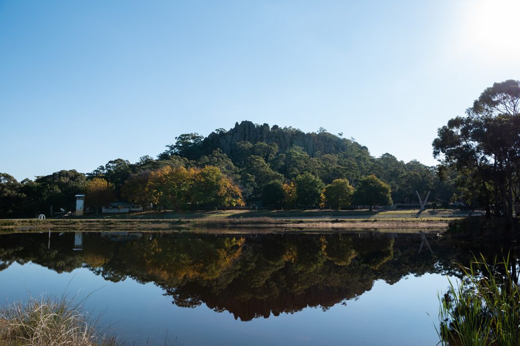
Nestled just an hour’s drive northeast of Melbourne, Victoria, lies a place steeped in mystery, natural beauty, and haunting legend: Hanging Rock. This striking granite rock formation, alongside its companion Mount Diogenes, forms the heart of a regional open space known as the Black Range State Park.
More than just a geological wonder, Hanging Rock is a site of deep Aboriginal significance, a muse for iconic Australian literature and film, and a captivating destination for adventurers and nature lovers. Ready to uncover its secrets?
The Enigmatic History of Hanging Rock
A Geological Marvel
Hanging Rock is a geological rarity, primarily composed of basaltic rock, formed approximately 6.25 million years ago by the rapid cooling of magma during volcanic eruptions. What you see today are the remnants of a mamelon, a unique volcanic formation where thick, pasty lava slowly squeezed up through a narrow vent.
Over millions of years, erosion has sculpted the softer surrounding rock, leaving behind the distinctive granite outcrops and “Gibraltar Pinnacles” that give Hanging Rock its unusual, almost suspended appearance. Its distinctive shape captivated surveyor William Naismith, who likely gave it its modern name after his 1853 survey.
Ancient Aboriginal Heritage
For thousands of years, Hanging Rock has held profound cultural significance for the Kulin Nation, particularly the Wurundjeri Woi Wurrung people, who are the traditional custodians of the land. They knew it by names like ‘Dandenong’ or ‘Yarra Yarra’, meaning ‘suspended rock’ or ‘rock suspended’.
This sacred site served as a vital gathering place for tribal meetings, trade, and ceremonies. The Kulin people would regularly feast on Bogong moths, which provided a rich source of protein during their annual migration from mid-August to early October. Records show Aboriginal people continued to visit Hanging Rock for ceremonies well into the 20th century, celebrating their enduring connection to this powerful landscape.
European Discovery and Reserve Status
Europeans first documented Hanging Rock in 1838 during Major Thomas Mitchell’s explorations. While gold miners camped nearby in the 1850s, the area’s official protection began much later. Hanging Rock Reserve was formally proclaimed on December 16, 1969, under the Crown Land (Reserves) Act, 1906, and is now managed by the Macedon Ranges Shire Council.
“Picnic at Hanging Rock”: Fact, Fiction & Filming
The Enduring Mystery
The name “Picnic at Hanging Rock” immediately conjures images of the famous 1967 novel by Joan Lindsay and Peter Weir’s chilling 1975 film adaptation. The story, set in 1900, tells of schoolgirls and a teacher who mysteriously vanish during a St. Valentine’s Day picnic at the rock.
While the book masterfully blurs the lines between fact and fiction, presenting itself as based on a true event, the mystery of the missing girls is entirely a work of the author’s imagination. It remains one of Australia’s most compelling fictional tales, forever intertwined with the real-life enigma of Hanging Rock.
Filming Locations
While the actual Hanging Rock provides the atmospheric backdrop, many scenes for the film “Picnic at Hanging Rock” were shot elsewhere. Key locations included private properties in the Dandenong Ranges, such as Sandridge Park and Glenburn, adding to the film’s evocative Victorian-era aesthetic.
Exploring Hanging Rock Reserve: Activities & Attractions
Hiking & Trails
Hanging Rock Reserve offers a range of walking tracks to suit all fitness levels, allowing you to immerse yourself in its unique landscape. Pick up a map at the Visitor Centre to guide your adventure.
- Summit Walk: The most popular trail leads directly to the top of Hanging Rock, offering breathtaking panoramic views across the Macedon Ranges.
- Base Walk (1.8km circuit): A gentle stroll around the base of the rock, perfect for families and those seeking an easier experience.
- Macedon Regional Park Trails: For more strenuous hikes, explore trails that connect to the wider Macedon Regional Park, including climbs to Mount Macedon.
Other Activities
Beyond hiking, Hanging Rock Reserve provides opportunities for various outdoor pursuits. Join a guided walk to learn about the ecology and cultural significance of the area, or explore at your own pace with self-guided options.
Horse riding and cycling are also popular ways to explore the extensive network of trails within the wider reserve. Check with the Visitor Centre for specific trail access and bike hire availability on weekends and public holidays.
Wildlife & Flora
The park is a haven for native Australian wildlife, including wedge-tailed eagles soaring overhead, colourful rosellas, and playful cockatoos. Keep an eye out for rare animals like the short-beaked echidna, powerful owl, and parma wallaby.
Botanists will appreciate the diverse flora, with over 370 plant species, including distinctive yellow gum, mountain geebung, and prickly heath, transforming the landscape with seasonal colours.
Planning Your Visit to Hanging Rock
Getting There
The easiest way to reach Hanging Rock is by car, with ample parking available on-site. The nearest major town is Romsey, and the popular tourist town of Woodend is also close by. Several coach operators offer tours from Melbourne, providing a convenient alternative.
Remember to fill up your fuel tank before arriving, as services at the reserve are limited.
Best Time to Visit
Hanging Rock is beautiful year-round, but the period from April to October generally offers pleasant weather for outdoor activities. The reserve is open daily from 9:00 AM to 5:00 PM (with variations for public holidays and events), but always check opening hours before your visit.
Winter brings a tranquil, dormant beauty to the native plants and animals, though fewer activities may be on offer. Summer can be warm, making early morning or late afternoon visits ideal.
Picnic & Dining Options
You can absolutely enjoy a picnic at Hanging Rock! While picnicking or lighting fires directly on the rock formation is prohibited due to its sacred status and for safety, designated picnic areas with tables and BBQ facilities are available at the base of the rock near the water.
Remember to practice “leave no trace” principles: take all your rubbish with you as there are no public bins. A rug or mat can enhance your comfort and protect you from insects.
Camping at Hanging Rock
While camping isn’t permitted directly on Hanging Rock itself, the wider Hanging Rock Reserve offers several campgrounds for those wishing to stay overnight and extend their exploration. These include:
- Wonga Hill Campground: Features six cabins, with a shelter and toilet (no power or water).
- Bosley’s Camp: Located near the main car park, offering barbecues and toilets (no power or water).
- Holland’s Campground: A short distance from Wonga Hill, with a shelter and toilet (no power or water).
- Redbank Camp: The most basic option, with toilets but no power or water.
Always check current opening hours and booking requirements with the Macedon Ranges Shire Council before planning your camping trip.
Safety & Preparedness
Hanging Rock is a wilderness area, so preparation is key. Always carry enough drinking water, food, and appropriate clothing for changing weather conditions. Mobile phone coverage can be limited or non-existent within parts of the park, so plan accordingly.
Stick to marked tracks, especially due to steep cliffs and loose rocks in some areas. For your safety, it’s not recommended to hike after dark, and inexperienced hikers or young children should always be supervised on longer trails.
Frequently Asked Questions About Hanging Rock
Can you picnic on top of Hanging Rock?
No, picnicking and lighting fires are not permitted on top of the rock formation itself due to its cultural significance and for safety reasons. Designated picnic areas are available at the base.
Is it safe to go hiking at Hanging Rock?
Yes, it is safe if you follow marked trails and come prepared. Be aware of weather changes, carry water, and avoid venturing off-track due to steep cliffs and loose rocks.
Can I get lost at Hanging Rock?
The reserve features well-marked tracks and clear trail markers. However, venturing off-marked paths is dangerous. Always carry a map and be mindful of sunset times as visibility can drop rapidly.
What type of rock is Hanging Rock?
Hanging Rock is primarily basaltic rock, a fine-grained igneous rock formed from rapidly cooled lava. It’s a mamelon, a unique volcanic feature sculpted by millions of years of erosion.
What should I pack for a picnic at Hanging Rock?
Bring your food, plenty of drinking water, a mat or rug for comfort, and a bag for all your rubbish. Remember, there are no bins, so you must take everything you bring with you when you leave.
What happens if it rains at Hanging Rock?
If tracks become wet or muddy, some areas can become dangerous due to slippery surfaces. It’s best to check the forecast and consider postponing or cutting short your visit if heavy rain is expected, as there are no shelters on the trails.
What if I get injured or lost?
In an emergency, call 000 immediately. Do not attempt to climb cliffs or venture into dangerous areas alone. If you have an EPIRB (Emergency Position Indicating Radio Beacon), activate it for assistance.